
Rabaul, New Britain
Located on the coast of a natural harbor on the eastern coast of New Britain, an island in the Southwest Pacific, Rabaul was a German colony in the 1900s that was captured by the Australians in World War I. Two nearby volcanoes, Vulcan and Tavurvur, erupted violently in 1937, destroying most of the city. After World War II started, it was captured by the Japanese in January 1942, after which it was transformed into a major stronghold with approximately 97,000 troops that would easily fend off Allied attacks until October and November 1943. While the Allies continued to advance towards Japan, they cut off Japanese supply routes to Rabaul and continued to bomb the city and surrounding area. It was officially surrendered at the end of the war. After the war was over, the city became a trading hub until Tavurvur erupted in 1994, once again destroying a large part of the city. Developments closest to the volcano were never rebuilt.
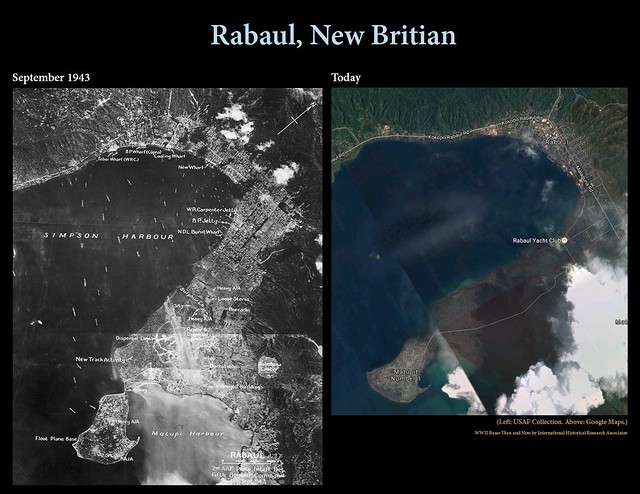
Click to enlarge. In the photo on the left, taken from Ken’s Men Against the Empire, Vol. I, is Rabaul and Simpson Harbor as they appeared in September 1943. At right is Rabaul today, taken from Google Maps.
Langley Air Force Base
Established in 1917 near Hampton, Virginia, Langley Field (named after American aviation pioneer Samuel Pierpoint Langley) remains one of the oldest air bases in continuous operation in the U.S. Its small airfield was expanded in the 1930s and continued to develop as World War II began. At the time the left image was taken, Langley was used as a training ground for new units, such as the 43rd Bomb Group, established in the U.S. military build-up before they entered the war.
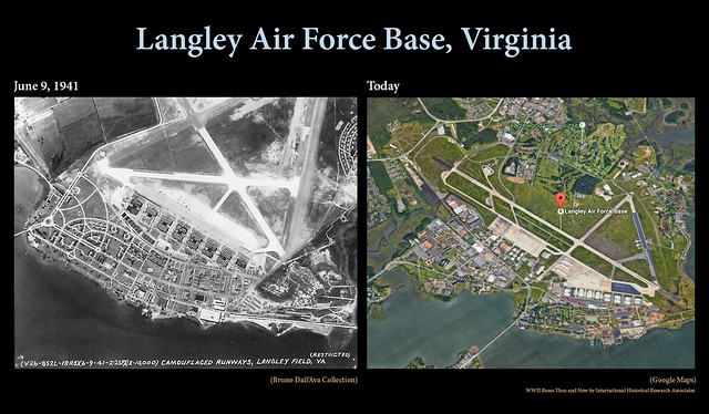
Click to enlarge. In the photo on the left, taken from Ken’s Men Against the Empire, Vol. I, is Langley Field in 1941. At right is Langley today, taken from Google Maps.
Boram Airdrome
On the northern coast of Papua New Guinea, Boram (referred to as East Wewak by the Japanese) was one of the four airdromes that made up the Wewak Complex built by the Japanese during World War II. The other three in the complex were Wewak, Dagua, and But. It was repeatedly attacked by the Allies between 1942 and 1945, and finally ended with the Australians securing Boram on May 22, 1945. These days Boram is the home of the Wewak Airport, also sometimes known as Boram Airport.
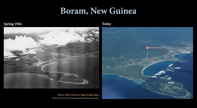
Click to enlarge. In the photo on the left, taken from Rampage of the Roarin’ 20’s, is Boram Airdrome after it was attacked by the 312th Bomb Group during the spring of 1944. At right is Boram today, taken from Google Maps.
Morotai Island
Approximately two years after the Japanese invaded Morotai Island, off Halmahera Island in east Indonesia, the 31st Infantry Division of the U.S. Army landed on Morotai on September 15, 1944. Two airstrips were built and Morotai grew into a major staging base for attacks on Japanese territory in the Philippine Islands. Almost a year later on September 9, 1945, the island became the site of the formal surrender of the 126,000 Japanese still in the Netherlands East Indies [now Indonesia]. The base became a large aircraft and vehicle graveyard after the war was over. Scrapping and smelting lasted until 1988.
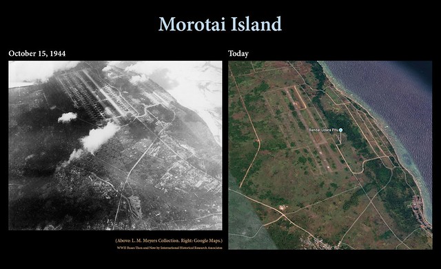
Click to enlarge. In the photo on the left, are the two airstrips at Morotai on October 15, 1944. At right is Morotai today, taken from Google Maps.
Ie Shima
Ie Shima was part of the Ryukyu Island chain, a trail of islands southwest of Japan. It was just west of Okinawa, and was captured by the Allies as part of the Battle of Okinawa. Before American units took over the base, the Japanese destroyed the runways and buried mines throughout the island to deter Allied attacks. Once it was under U.S. control, various engineer aviation battalions were hard at work to make the island habitable for units that were due to move to the island in June. In August, Ie Shima was a stop for the Japanese surrender delegation on their way to Manila. These days, the U.S. Marine Corps operates a military training facility on part of the island, while civilians reside on the rest of it.
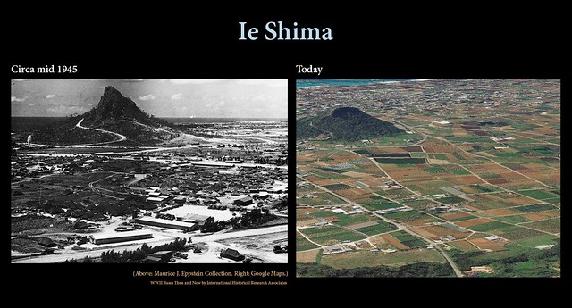
Click to enlarge. In the photo on the left, taken from Warpath Across the Pacific, is the 345th Bomb Group’s camp area at Ie Shima in the summer of 1945. At right is Ie Shima today, taken from Google Maps.
Buka Island
Buka Island is part of the Solomon Island chain in the southwest Pacific, on the opposite end of the chain from Guadalcanal. After being claimed by the Germans in 1885, Buka was turned over to Australia in 1920. The Japanese seized Buka on March 9, 1942 and built an air base that grabbed Allied attention in June 1943 when preparations for Operation Cartwheel were in the works. A small canal separated Buka from the island of Bougainville, which was to be the site of a major invasion, and up-to-date reconnaissance of the two islands was required beforehand. That reconnaissance mission turned into one of the most dramatic moments of the Pacific war when Capt. Jay Zeamer, Jr. and his crew were attacked during their photomapping mission on June 16, 1943. In the end, Zeamer and his bombardier, 2/Lt. Joseph R. Sarnoski, were awarded the Medal of Honor (Sarnoski’s was posthumously awarded) and the rest of the crew was awarded the Distinguished Service Cross for getting those photos while under fire. Contrary to internet lore, this photo was not taken during that mission. Buka remained under Japanese control until September 1945. It later gained independence from Papua New Guinea in 2005.
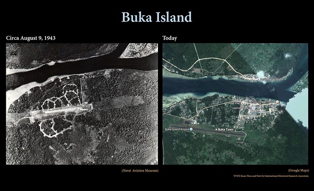
Click to enlarge. In the photo on the left, taken from the Naval Aviation Museum, the Buka airfield in August 1943. At right is Buka today, taken from Google Maps.
Sources and additional reading:
- http://www.pacificwrecks.com/provinces/png_rabaul.html
- http://www.jble.af.mil/Mission-Partners/Air-Force
- http://www.pacificwrecks.com/airfields/png/boram/index.html
- http://www.pacificwrecks.com/provinces/irian_morotai.html
- https://en.wikipedia.org/wiki/Morotai
- http://www.pacificwrecks.com/provinces/japan_ie_shima.html
- http://www.pacificwrecks.com/airfields/japan/ie_shima/index.html
- https://en.wikipedia.org/wiki/Ie_Shima_Airfield
- http://www.pacificwrecks.com/airfields/png/buka/index.html
- http://www.pacificwrecks.com/provinces/bougainville_buka.html
- https://www.britannica.com/place/Buka-Island
- https://irandpcorp.com/products/345bg/
- https://irandpcorp.com/products/312bg/
- https://irandpcorp.com/products/43bg1/
- http://zeamerseagerbeavers.com/

We might complain about the effects of weather on flying, but an erupting volcano takes it to, literally, a whole new level!
LikeLike
Quite right!
LikeLike
The Pacific Islands must be littered with these old places.
LikeLike
They certainly are!
LikeLiked by 1 person
In some you notice a drastic change and others – not so much.
LikeLike
Yeah. It’s interesting seeing how much has changed in 70+ years.
LikeLiked by 1 person
Pingback: The Same Places, 70+ Years Apart—Six More WWII Bases Then and Now | Meccanica Mekaniikka Mecanică
Pingback: The Same Places, 70+ Years Apart—Another Six WWII Bases Then and Now | IHRA
Pingback: Repost: The Same Places, 70+ Years Apart—Six More WWII Bases Then and Now | IHRA