
This week, we wanted to take a look at how much several World War II bases from the Pacific Theater (as well as one from the U.S.) have changed since the war ended.
Hunter Army Airfield
Located in Savannah, Georgia, Hunter Field was originally a municipal airport built in 1929. It was named Hunter Municipal Airfield in May 1940 after a World War I flying ace from Savannah, Lt. Col. Frank O’Driscoll Hunter. Soon afterwards, an Army Air Corps base was built and several units, the 3rd and 27th Bomb Groups as well as the 35th Air Base Group, would call it home for a short time. The 312th Bomb Group was another unit that did their aircraft training at Hunter Air Base (so renamed on February 19, 1941). Today, there are about 5000 soldiers at Hunter Army Airfield, including the Coast Guard’s Air Station Savannah.

Click to enlarge. In the photo on the left, taken from Rampage of the Roarin’ 20’s, is the base where bomb groups such as the 312th were activated. At right is Hunter Army Airfield today, taken from Google Maps.
RAAF Base Amberley
What is now the Royal Australian Air Force’s largest base was under construction during most of World War II. Amberley, located southwest of Brisbane, was named by an immigrant farmer in the 1850s after his hometown in England. Airport construction began in 1939 and continued through 1944. During the war, the base briefly housed many Australian and U.S. units, including the 22nd and 38th Bomb Groups.
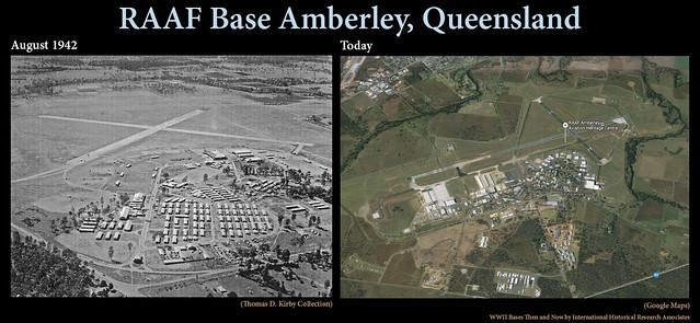
Click to enlarge. At left is airfield at Amberley during the early part of WWII, taken from Revenge of the Red Raiders. The image on the right is a current view of RAAF Base Amberley, taken from Google Maps.
Corregidor Island
Originally Spanish territory, the island of Corregidor was incorporated into U.S. territory after the Spanish-American War. It stayed that way until Japanese forces invaded the island in 1942, leading to the unconditional surrender of the Allies in the Philippines on May 6, 1942. Finally, in early 1945, the Allies took back the island. These days, Corregidor is part of the Philippines National Park, with several historic landmarks scattered about the island.
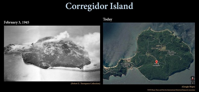
Click to enlarge. (Left) A 43rd Bomb Group strike photo of Corregidor after it was bombed by the Group, taken from the IHRA archives. (Right) This satellite image of the island shows how it has changed since World War II. Image taken from Google Maps.
Manila, Philippines
Manila was also a Spanish territory that was given to the U.S. after the Spanish-American War. From 1935-1941, it was Gen. MacArthur’s base during his time as a military advisor. The city was attacked by Japanese on December 8, 1941, and, after repeated bombings, it fell into Japanese hands in January 1942. Three years later, the U.S. returned to Manila and fought a bloody month-long battle to recapture it, destroying much of the city in the process. This picture was taken at the tail end of the conflict. The city has since recovered and is now a major urban center in the Pacific, the capital of the Philippines, and has a population of over 1.5 million people.
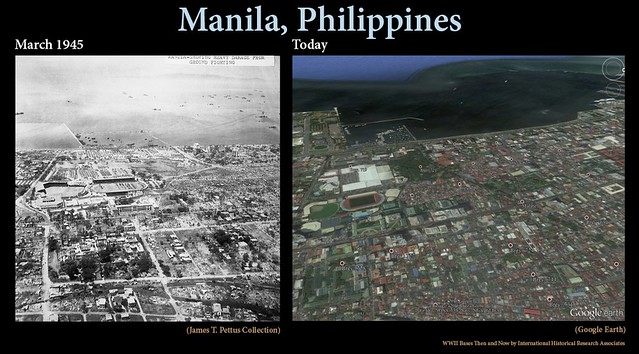
Click to enlarge. The photo on the left, taken from the IHRA archives, shows the destruction after Manila was bombed. At right is a satellite image of a rebuilt Manila taken from Google Earth.
Wakde Island
Before the Japanese set foot on Wakde Island in April 1942, it may have been inhabited by a small native population. Over the next year, much of the foliage on the island was cut down to make space for a runway that was 5400 feet long and 390 feet wide. The Japanese leveled more of the island to build 100 pillboxes, bunkers and other defenses. On May 15, 1944, the fight over Wakde began. All but four Japanese soldiers stationed there fought to the death. Wakde was further expanded by the Allies, almost completely clearing the island of vegetation in the process. Today, the island is uninhabited.
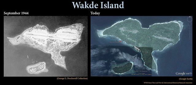
Click to enlarge. The photo on the left, from Rampage of the Roarin’ 20’s, shows Wakde Island after its development as an Allied base. The image on the right is from Google Earth.
Nadzab
This base, located north of Lae, started out as a tiny native village that was eventually populated by German Lutherans of the Gabmatzung Mission in 1910. A small airfield was later established. The Japanese captured Nadzab in 1942 and occupied it until early September 1943 when Gen. MacArthur ordered Operation Postern to be carried out. Once Nadzab was in Allied hands, it was expanded into a huge airbase with five airstrips. As the war wound down, Nadzab was redesigned as an aircraft boneyard. Today, it serves as a small regional airport.
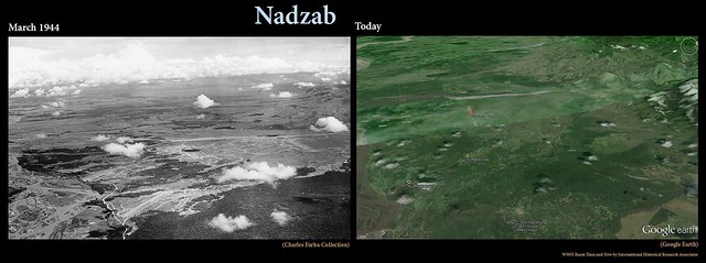
Click to enlarge. At left, four of Nadzab’s five airstrips can be seen in this photo from IHRA. Today, the only sign of this former base is the single runway seen slightly left of center. The satellite image is from Google Earth.
Sources and additional information about these WWII sites:
- http://www.stewart.army.mil/units/history.asp?id=186
- http://www.ozatwar.com/airfields/amberley.htm
- http://www.airforce.gov.au/RAAFBases/Queensland/RAAF-Base-Amberley/?RAAF-tixcqOo+FfSGpvktTn4V2/n/6DYHtD+g
- http://corregidorisland.com/history.html
- http://www.pacificwrecks.com/provinces/philippines_corregidor.html
- http://www.pacificwrecks.com/provinces/philippines_manila.html
- http://www.pacificwrecks.com/airfields/indonesia/wakde/index.html
- http://www.pacificwrecks.com/provinces/irian_wakde.html
- http://www.pacificwrecks.com/airfields/png/nadzab/
- http://www.pacificwrecks.com/provinces/png_nadzab.html
- http://corregidor.org/heritage_battalion/lowe/ch_5.html

A really interesting post. Thank you so much. There is nothing as interesting as the effect of time on human structures such as these.
LikeLike
Glad you enjoyed it! Agreed, it’s very interesting to see what humans and nature do after going through war. We thought the transformation of Wakde Island was especially fascinating.
LikeLike
Very interesting and enjoyed seeing the before and after!
LikeLike
Thanks! It’s great that we have the technology available to see these locations from so many miles away.
LikeLiked by 1 person
It’s always amazing to see the remains of these places. I can imagine many sites on the smaller islands are relatively intact, as they are not targeted by the developer.
LikeLike
You’re probably right. The remote locations of bases and battles in the Pacific makes it less likely that they’ll be developed (much, if at all). Very different from what’s happening in your area.
LikeLiked by 1 person
Most definitely. Many of ours are disappearing, as you know!
LikeLike
It’s very unfortunate.
LikeLiked by 1 person
Pingback: International Historical Research Associates | Wakde Island: Then and Now
When I view comparisons such as these – and especially of abandoned Wakde Island – my heart cries for the souls who perished there and perhaps may still be in unmarked graves.
LikeLike
There are too many that are still far from home. DPAA and others are trying to fix that. http://www.dpaa.mil/
LikeLiked by 1 person
Pingback: International Historical Research Associates | Then and Now: Hunter Army Air Field
Pingback: Repost: The Same Places, 70+ Years Apart—Six WWII Bases Then and Now | IHRA
Pingback: Looking Back at Our Top Posts of 2016 | IHRA
Pingback: The Same Places, 70+ Years Apart—Another Six WWII Bases Then and Now | IHRA